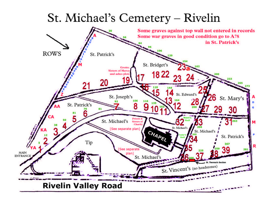
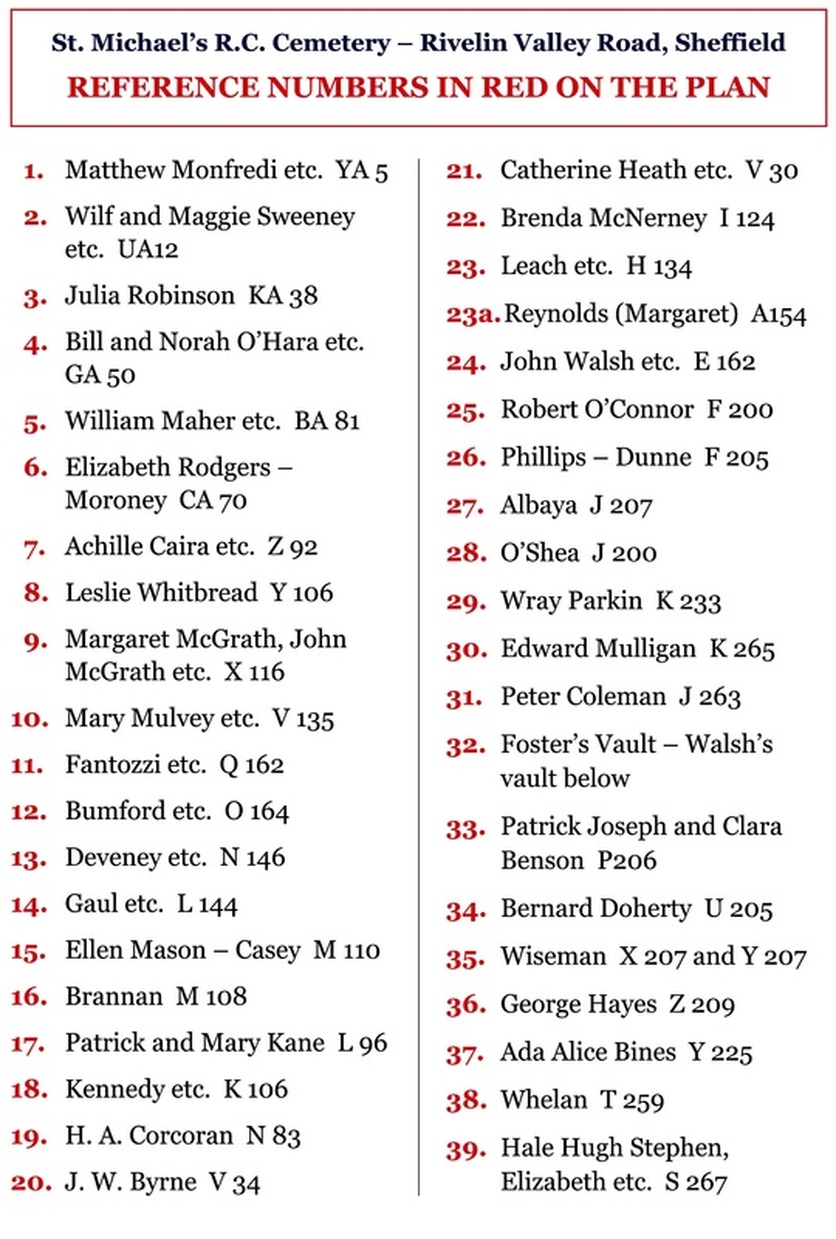
Overhead Plan - the large red numbers are prominent headstones (see key below).

The large red numbers are prominent headstones - see key below. Rows are in two's, sometimes even, sometimes odd numbers. Plan not to scale and not strictly accurate.
Further detail regarding layout of graves
The area round the chapel has a separate plan with individual graves marked, because the numbering system was not very accurate in this area. The area below the flagged path, from the drive to below the chapel, is where the most recent new graves may be found. Space is running out. I hope to upload to the website this plan area before Spring 2011.
The cemetery was originally set out in a latitude and longitude system. Row A is the first row at the top of the hill. The graves are numbered using every second number e.g. 2, 4, 6, 8 etc. However, for some reason, some rows were numbered 1, 3, 5, 7 etc. What is more, the numbering often changes from even numbers to odd numbers, or vice-versa part way along the row. After row Z they continued AA, BA, to YA.
The various sections were named (a) to assist in finding the general area, although that was defeated by splitting St. Patrick’s section into three separate sections – two just inside the gate and one at the very far end of the cemetery and (b) for differential pricing – the nearer to the chapel the more expensive although the prices have never been high when compared to the municipal cemeteries.
The numbering of the graves ignores the sections, e.g. in row A, St. Patrick’s section contains numbers A22 to A96, then St. Brigid’s section contains A98 to A194 and St. Mary’s section contains A207 to 251 then A252 to 255 (change from evens to odds).
There is then a St. Vincent’s section A258 to A333. This must be at the very bottom, where indicated on the plan (page v), alongside the main road. There are no headstones to locate any of the graves. St. Vincent’s section (which appears to include some random graves around the various walls of the cemetery – all with no headstones to locate them) was for paupers who were buried in very cheap coffins in common graves, some holding unbelievable numbers of totally unrelated persons, often from the “Union” or Workhouse, of which the main one was in Herries Road, now part of the Northern General Hospital, but there were others.
The best way to find a particular grave is to refer to the computer printout from which graves with headstones can be identified and from which graves without headstones can be worked out by counting in two’s right or left and in rows up and down from the reference given for the nearest grave with a headstone.
As a general guide which may sometimes help in locating graves which do have a headstone, without referring to the entire printout, a list of prominent graves is attached with numbers in red on the plan (page v). A few rows are also identified at the extreme left and extreme right, showing how they run parallel to the very top wall, sloping down to the right.
The latest burial area in St. Michael’s section on the right of the drive towards the chapel, used to have a ‘no-go’ area in the middle where large bushes and stones made it necessary to bypass the centre and start numbering again further on. Unfortunately, this led to the numbers becoming hopelessly out of line with rows higher up and generally confusing. When the central area was cleared and put into use, the numbers just did not meet each other. That is why the separate plan with each grave identified by a separate rectangle, with a thick black line round those that had headstones when the plan was last updated, is essential. That is particularly so because some of the graves were not accurately laid in line with those above, to add to the confusion. A further reminder - please take extra care when walking away from the paths as some headstones may be unstable. Always wear strong footwear and take extra care on the slopes, especially near headstones.

